

THE Pasig River is being reframed as Metro Manila’s blue thread, a continuous waterway that can stitch together livability, climate resilience and urban prosperity.
A new Asian Development Bank (ADB) report for the Pasig River Public Open Space Framework lays out an ambitious vision: a connected system of esplanades, parks, ferry links and green bridges that together could transform a 500‑meter corridor along the 25.4 km river into a resilient public realm serving more than half a million residents.
If realized, the change would be more than cosmetic. It can bring about measurable environmental and economic returns while improving daily life for communities that border the river.
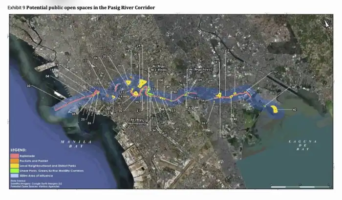
At the center of the plan is the long esplanade program, a nine‑segment, riverside walk-and-cycle spine being led by the Department of Human Settlements and Urban Development (DHSUD).
The esplanade is conceived as a continuous 24–25 km linear public realm, divided into nine geographic sections from the Port Area and Intramuros in the west through Makati and Pasig to the Taytay frontier in the east.
DHSUD’s preliminary cost framing places the full esplanade’s capital cost in the medium‑to‑high range, with phasing already under way on several segments. The report notes environmental caveats such as piling and heavy concrete works can risk river ecology and hydrology and calls for nature‑positive design where possible.
Complementing the esplanade is Mapalla, the proposed Manila Bay‑Pasig River‑Laguna Bay ferry network aimed at making water transit a regular and reliable part of urban mobility. Mapalla’s base scenario envisions roughly 21 ferry stations on the Pasig and Marikina reaches and 44 vessels, with projected daily ridership in the tens of thousands once the system scales.
The ferry plan explicitly links transport expansion to public‑realm upgrades. Ferry landings become pocket parks, plazas and last‑mile nodes in the new riverfront network.
Green bridges
Beyond the spine, the report catalogs dozens of site‑level interventions: pocket parks at ferry stations, neighborhood linear parks through Mandaluyong’s proposed 5‑km linear network, larger district parks, and even wetland‑style parks tied to the proposed 4PH housing developments on the river’s fringes. Dozens of green bridges — pedestrian and cyclist crossings with canopy and shade — are proposed to knit the two banks together, prioritizing dense communities that lack safe crossings. Tactical, low‑cost interventions and barangay‑level plazas are also on the longlist: tactical urbanism, street closures for weekend markets, and temporary placemaking can quickly demonstrate benefits while larger projects proceed.
The economic case is straightforward. International studies cited in the report show property uplifts in the single‑digit to double‑digit percentages after major park or waterfront investments. Local planners expect similar value capture in commercial nodes adjacent to the esplanade.
Meanwhile, nature‑based solutions embedded in parks and linear wetlands can reduce urban heat and provide sponge‑city functions to attenuate floods, an urgent priority in Metro Manila. Flood maps and climate models show high flood exposure on the midstream and downstream river reaches and projected warming and sea‑level rise risks for Metro Manila from 2040–2070.
The report highlights cooling effects from tree‑rich parks, reducing near‑surface temperatures by degrees that matter for health and productivity, and emphasizes multi‑functional park design.
Yet the report is candid about trade‑offs and governance risks. Building large concrete esplanades can damage hydrology and displace informal riverside livelihoods unless careful environmental assessments and inclusive resettlement plans are applied.
Institutional fragmentation is an ongoing challenge: the Inter‑Agency Council for the Pasig River Urban Development (IAC‑PRUD) is the coordinating body, but the corridor intersects multiple national agencies, the Laguna Lake Development Authority, MMDA and six riparian LGUs whose plans, codes and capacities are uneven.
Operation and maintenance costs are another practical hurdle: parks and promenades require recurring O&M budgets. Several governance models such as public, private, community or mixed management are proposed to share responsibilities and risks.
The Pasig can be more than a river; it can be the city’s connective tissue. The ADB report gives Manila the blueprint. Its implementation means safer walking and cycling corridors, cooling green spaces in heat‑stressed neighborhoods, improved ferry access, and income from vendors and cultural programming for the residents.
For policymakers and funders, public open space becomes an asset that generates social, environmental and fiscal returns — from reduced health costs and flood damage reduction to expanded tax bases as neighborhoods uplift.
The article was originally published in The Manila Times and written by Ludwig Federigan.
If you like this article, share it on social media by clicking any of the icons below.
About Post Author


More Stories
Camella Honors GenSan Heritage and Homegrown Spirit at Tuna Festival 2026
Gabriel Formoso named National Artist for Architecture
Makati: The city that is learning to walk again